Alaska Storyteller Photography

© Robert M. Braley Jr., Photographer


Home

United States

Alabama

Alaska

Anchor Point

Anchorage

Alaska Flag

Alaska Natives

Big Lake

Chicken

Chickaloon

Chugiak

Copper Center

Cold Bay

Cooper Landing

Cordova

Cottonwood Creek

Civil War Alaska

Delta Junction

Denali Park

Elmendorf AFB

Eureka

Fairbanks

Glennallen

Hatchers Pass

Healy

Houston

Homer

Hope

Hyder

Kenai

King Cove

Kodiak

Lake Louise

Nenana

Ninilchik

North Pole

Northway Junction

Palmer

Rabbit Slough

Richardson Highway

Russian America

Sand Point

Seward

Sitka

Soldotna

Sterling

Talkeetna

Tok

Tok Cut-Off

Trapper Creek

Captian Cook

Southeast

Swan Lake

Valdez

Wasilla

Willow

Yakutat

Alaska Highway

Alaska Highway 2

Alaska Highway 3

Alaska Highway 4

Alaska Highway 5

Alaska Highway 6

Alaska Highway 7

Alaska Highway 8

Alaska Highway 9

Alaska Highway 10

Alaska Highway 11

Alaska Highway 12

Alaska Highway 13

Historic Mileposts

Historic Mile 941

Historic Mile 1010

Historic Mile 1016

Historic Mile 1067

Historic Mile 1072

Historic Mile 1083

Historic Mile 1093

Historic Mile 1152

Historic Mile 1164

Historic Mile 1188

Historic Mile 1202

Historic Mile 1229

Historic Mile 1221

Historic Mile 1225

Historic Mile 1249

Historic Mile 1254

Historic Mile 1257

Historic Mile 1264

Historic Mile 1306

Historic Mile 1309

Historic Mile 1314

Historic Mile 1332

Historic Mile 1422

Arkansas

Arizona

California

Bakersfield

Fort Crook Museum

George AFB

Klamath AFS

Klamath WWII Radar

Redwood NP

San Francisco

Samohi

Santa Monica

Venice

Whiskeytown

Colorado

Connecticut

Delaware

Florida

Georgia

Hawaii

Pearl Harbor

Kansas

Kentucky

Idaho

Idaho City

Illinois

Indiana

Louisiana

Iowa

Ohio

Oregon

Ashland

Lithia Park

Oregon Coast

Maine

Maryland

Massachusetts

Michigan

Minnesota

Mississippi

Missouri

Montana

Nebraska

Nevada

New Hampshire

New Jersey

New York

New Mexico

Ruidoso

North Carolina

North Dakota

Oklahoma

Pennsylvania

Rhode Island

South Carolina

South Dakota

Tennessee

Texas

Utah

Vermont

Virginia

Washington

Anacorties

Anacortes WA

Centralia WA

Chehalis WA

Elbe WA

Lewis County WA

Mt Rainer

Olympia WA

Steilacoom WA

Tacoma

Washington D.C.

Wisconsin

West Virginia

Wyoming

Canada

British Columbia

100 Mile House

108 Mile House

Hope BC

Stewart BC

Chetwynd

Hudsons Hope

Pouce Coupe BC

Dawson Creek AH0000

Taylor AH0035

Fort St John AH0047

WonOWon AH0101

Pink Mountain AH0143

Fort Nelson AH0300

Tetsa River AH0375

Toad River AH0422

Summit Lake 0392

Muncho Lake AH0456

Liard Hot Springs AH0496

Smith River AH0514

Contact Creek AH0588

BC Border AH 0627

Dawson Creek VC

Dawson Creek DT

Yukon

Yukon Border AH0627

Watson Lake AH0635

Cassiar Hwy AW0649

Nugget City AH0650

Rancheria River AH0710

Cont Divide Lodge AH0721

Swift River AH0733

Teslin AH0604

Johnsons Crossing AH0836

Marsh Lake AH0890

Whitehorse AH0905

Whitehorse AH0915

Canyon Creek AH0941

Beaver Creek

Crete

Equator

Israel

Products

Nature

Animals

Flowers

Landscapes

Sunset

Wildflowers

Wildlife

Fish

Birds

Albatrosses

Canada Goose

Comorants

CaracarasFalcons

DucksGeeseSwans

Frigatebirds

Grebes

Loons

Osprey

PartridgesGrouse

Pelicans

redwingedblackbird1

HawksKitesEagles

ShearwatersPetrels

StormPetrels

Bats

Vultures

Mammals

Black Bear

bison

BitternsHeronsEgr

Caribou

Carnivorans

Cetaceans

Dall Sheep

Deer

Moose

Mountain Goat

Seals Sea Lions Walrus

Orca

Pikas Hares Rabbits

Polar Bear

Primates

Raccoons

Rodents

Great blue heron

Shrews

Bears

Beaver

Ungulates

Weasels

Military

C-17

T-6G

T-33

P-51 Mustang

KC-135

HH-60

F-86

F-80

C-47

HC-130N

C-130H

C-130E

C-123J

Alaska National Guard

Alaska Air National Guard

Camp Murray

Alaskanized

Ladd AFB

AKNG Museum

U-Tapao

Pixels

links

About

Policy/Copyright

Contact

Photo Sizes

Alaska Highway Sign Forest
Alaska Highway Historic Mile 635


Become a image contributor at Dreamstime (as your stock photography agent) and start selling your camera and/or cell phone travel and other images. Learn how by clicking on a banner above.

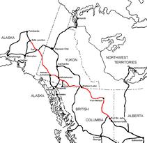
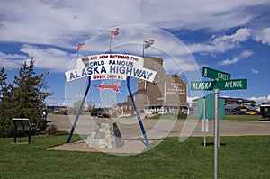
The Alaska Highway
Dawson Creek, British Columbia to Delta Junction, Alaska
(historical routes, heritage sites, sightseeing, driving tour)
Pioneer Road - Contract Road - Public Road

Yukon Territory, Canada

Alaska Highway Sign
Alaska Highway Historic Mile 0

Historic Mile 635 - Watson Lake

  • During the early years of World War II, the existing airfield at Watson Lake was expanded to accommodate the steady stream of fighter aircraft en route from the United States to Russia along the Northwest Staging Route.

Watson Lake, Canada, historic airport hangar
Alaska Highway Historic Mile 635

Watson Lake Yukon Territory Canada
Alaska Highway Historic Mile 635

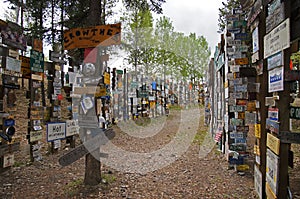
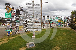
The Signpost Forest may be Watson Lake’s most famous attraction, started in 1942 by Carl Lindley, a homesick GI, while working on the Alaska Highway. He erected a sign pointing to his hometown of Danville, IL. The collection of signs is constantly being added to each year by visitors who wish to promote their own communities. The Town of Watson Lake maintains the Sign Post Forest which is known as one of The Yukon’s most famous landmarks with over 72,000 unique signs.

Alaska Highway Sign Forest
Alaska Highway Historic Mile 635

Alaska Highway Sign Forest
Alaska Highway Historic Mile 635

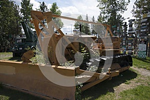
Alaska Highway Interpretive Center is open daily during the summer months, located behind the Signpost Forest. The center provides information as well as an exceptional display of photos, and other audiovisual presentations. It is managed by Yukon Tourism and is one of five centers in the Yukon. 867-536-7469

Air Force Lodge has quiet and clean rooms, freeWi-fi, free coffee and tea. These 1942 pilot quarters were lovingly and fully restored. They are on the Alaska Highway near the Police station. 867-536-2890

Watson Lake is the first Yukon community encountered by the northbound traveler and is the second largest town in the Yukon. It is a comfortable day’s drive from Fort Nelson or Whitehorse.
Watson Lake is a popular stopover point, it has several hotels, campgrounds, service centers and a heated swimming pool that is open in the summer.

In 1898, 14 year old Francis (Frank) Gilbert Watson, an American from Lake Tahoe, came to the Yukon with his father Robert Montgomery Watson. They traveled the Chilkoot Trail route to Dawson City and had a successful Gold Mine in the Klondike. Unfortunately, like many other gold miners of the day their mine was flooded out in 1905 and Frank & Robert decided to return home to Lake Tahoe. A few years later Frank returned to The Yukon through Wrangell, Alaska and the Stikine and Dease Rivers. This brought him to the Liard River Valley near what is now the Town of Watson Lake. It was here he met Adela Stone, a formidable & well-known Kaska woman. Because of Frank’s relationship with Adela, the Kaska people allowed Frank to trap, prospect and settle in the area. Frank and Adela Watson have long been recognized as key figures in the early development in this part of the Yukon.

Watson Lake grew from a small isolated outpost to a thriving community when the Alaska Highway was routed through its center. It was the accommodation and supply center for the building of this section of the highway. In 1942 Watson Lake became an important transportation hub and is still the communication and distribution center for the Southern Yukon.

Watson Lake Public Campground on Alaska Highway north of Watson Lake  3 km/2 mile side road. 55 camp sites with 12 pull through sites, water, picnic shelters, toilets, firepits, hiking trails.  Fee area.

Downtown RV Park
Alaska Highway Historic Milepost 635


This is one of only three commerical RV Parks were I stay while traveling on the Alaska Highway. They are close to Whitehorse, have free wireless internet, and really great discounts on fuel and propane for those that stay in the park overnight. Very customer pleasing.

The bathrooms here are lovely and airy; spacious showers have wooden benches. Campsites are next to one another in an open gravel area which has trees at the perimeter. This campground is right in the centre of Watson Lake. There is a pet walkin area.

In Watson Lake, north off highway 97 (main road).

  • Operator or sponsor is: Commercial
  • Nearby town or city: Watson Lake
  • Total campsites: 84
  • Power water and sewer campsites available
  • Pull through campsites available
  • 30 amp. service available
  • WiFi
  • TV hookups
  • Tables provided at campsites
  • Free showers
  • Tap water available
  • Flush toilets
  • Laundry facilities
  • Wheelchair access
  • Concession or store at campground

More Information and photo's at CampScout.com

More Information and photo's at CampScout.com

Website powered by Network Solutions®