The first people to live in the Matanuska Valley, where Palmer is located, were the Dena'ina and AhtnaAthabaskans. They moved throughout the area, living a subsistence lifestyle and trading with other native groups. Their trade routes were along the Matanuska River. Russians came to Alaska in 1741 and brought the Russian Orthodox religious tradition to the indigenous peoples of the region. In the early 1890s, an entrepreneur named George W. Palmer built a trading post on the Matanuska River, near present-day Palmer. The town was later named after Palmer.
In the late 19th century, the U.S. government began to take interest in the Matanuska coal fields located north of Palmer. This interest sparked financiers to consider constructing the Alaska Central Railroad in 1904. The advent of World War I created a need for high-quality coal to fuel U.S. battleships, and by 1917 the US Navy had constructed rail from the port of Seward to the Chickaloon coal deposits. At the end of World War I, the U.S. Navy distributed land in the coal fields to war veterans and additional land was opened to homesteading. Farmers, miners and homesteaders began to populate the area. The Palmer Post Office was opened July 6, 1917, under the name of Warton. With railroad accessibility, new markets for agriculture began to open up for farmers in the Matanuska Valley.
In one year, Palmer transformed from a mere whistle stop rail siding to a planned community with modern utilities and community services. Eleven million dollars from Federal Emergency Relief Administration was spent to create the town of Palmer and relocate 203 families from the hard hit Iron Range region of Michigan, Minnesota and Wisconsin. Families traveled by train and ship to Palmer, arriving in May 1935. Upon their arrival they were housed in a city tent during their first Alaskan summer. Each family drew lots for 40-acre (160,000 m2) tracts and their farming adventure began in earnest. The failure rate was high, but many of their descendants still live in the area and there are still many operating farms in the Palmer area, including the
In addition to an agrarian heritage, the colony families brought with them Midwest America's small-town values, institutional structures, and a well-planned city center reminiscent of their old hometowns in Minnesota, Wisconsin, and Michigan. Many of the structures built are now in a nationally recognized historic district. Construction of the statewide road system and the rapid development of Anchorage has fueled growth around Palmer. Many Palmer residents commute 45 minutes to work in Anchorage.
Geography
Palmer is 42 miles (68 km) northeast of Anchorage on the Glenn Highway. It lies on the north shore of the Matanuska River, not far above tidewater, in a wide valley between the Talkeetna Mountains to the north and the Chugach Mountains to the south and east. Pioneer Peak rises over 6,000 feet (1,800 m) above the town, just a few miles south. East of Palmer is Lazy Mountain, and standing behind that is Matanuska Peak. Lazy Mountain, Matanuska Peak, and Pioneer Peak are all a part of the Chugach Range. North of Palmer are the Talkeetna Mountains. Hatcher Pass, a local favorite for hiking, skiing and other recreational activities, is located in this mountain range about 22 mi (35 km) from Palmer.
According to the United States Census Bureau, the city has a total area of 3.8 square miles (9.8 km2), all of it land. Palmer and Wasilla are the two major old-town cores of the Matanuska-Susitna Valley. Population of the area has grown dramatically in the past decade; Borough officials estimate the local population at 8,000.
The view traveling toward Anchorage from Palmer. Pioneer Peak is to the left with Twin Peaks to the right of Pioneer. The "Ghost Forest" of the Palmer Hay Flats State Game Refuge is shown in the foreground. These trees died from the subsidence that occurred in the area as a result of the Great Alaska earthquake of 1964.
Climate
Palmer has a climate similar to that of Anchorage, although with low temperatures that are on average 1.4 °F (0.8 °C) cooler and highs 0.8 °F (0.4 °C) warmer. August is the wettest month both by total precipitation and number of days with precipitation, and likewise, April is the driest. On average, over the course of a year, there are 28–29 days of sub-0 °F (−18 °C) lows, 22–23 days of 70 °F (21 °C)+ highs, and 0.8 days of 80 °F (27 °C)+ highs. The town straddles the border between USDA Plant Hardiness Zones 4b and 5a, indicating the coldest temperature of the year is typically around −20 °F (−29 °C).[7] Palmer is flanked by two glaciers, the Matanuska Glacier and the Knik Glacier. Wind blows through the Matanuska and Knik River Valleys into the town frequently. If there is a substantial snowfall, it will often sit for several days before most of it is blown away. These warm winds can raise winter temperatures for a couple days at a time, and are often called Chinook Winds, by the local people.
Arts and culture
Alaska State Fair
Palmer is most noted in Alaska as the location of the annual Alaska State Fair, where Palmer's agricultural spirit lives on. The Alaska State Fair holds contests for largest vegetable in several categories, and many national and even world records have been recorded at the fair, with the cabbage, radish, spinach and lettuce categories usually dominating local interest. There are rides and festivities, local artists on display, local venders and food trucks, and especially popular US artists at the ConcoPhilips Borealis Theatre. In 2008, Scott Robb of Palmer won 1st place and a $2,000 prize for his 79.1 lb (35.9 kg) cabbage.
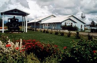
Palmer Museum of History and Art
Palmer hosts a log cabin Visitor Information Center in the heart of downtown that entertains more than 35,000 visitors each year. Each summer, the visitor center employs a full-time gardener to maintain the 2 acres (8,100 m2) of public gardens that showcase more than 600 locally grown plant varieties. The Palmer Museum of History and Art is located in the Visitor Information Center and offers visitors a chance to view artifacts from Palmer's history, provides maps to historical places to see and stocks guidebooks for more information on local attractions.[
The Church of a Thousand Trees
A couple of blocks away from the Visitor Information Center is the United Protestant Church (aka The Church of a Thousand Trees), a Presbyterian church. It was built in 1936-37 and is one of the 17 structures that contribute to the National Register's Matanuska Colony Historic District.
Friday Fling
A summertime event that was postponed 2020 summer because of COVID19 regulations, the Friday Fling is a local downtown Palmer event that takes place around the Public Library and Train Depot. Every Friday of the summer there is live music from students or local artists, local food trucks and vendors, and sometimes even rides. There is a large attraction due to the farmer's market kind of vibe that attracts a lot of do-it yourselfers and small business supporters in the area. Things from peanut brittle, local honey, soap to homemade carvings and art are sold there. A date spot for the teens.
Parks and protected areas
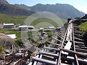
Twelve miles north of Palmer is Hatcher Pass, a scenic mountainous pass that's been established as a state park and is home of the Independence Mine. It serves as a local back-country area for skiers, snowboarders, snowmachiners, and hikers as well as a tourist attraction in the summer months.
The area is also home to the Kepler-Bradley Lakes State Recreation Area, which grants access to numerous small lakes,[14] the Finger Lake State Recreation Area, and a number of city parks.
Around 1880, George Palmer established a trading station at this site on the Matanuska River.
Palmer is a fertile farmland that was settled by families from the Midwest as part of the New Deal relief program in 1935. Touring Palmer you will discover the history of these early "colonists" and see the legendary, gigantic vegetables.
Palmer is a picturesque little town with an agricultural flair. It provides a wide range of hotels, motels, restored inns, bed and breakfasts and camper parks. Two golf courses offer views of the mountains and Knik Glaicier.
While the Knikatnu native peoples of Upper Cook Inlet have lived in and around what is now the Palmer Hay Flats for centuries, there are currently no settlements within the refuge; although evidence of their historic occupation exists along the bluffs above the Hay Flats. Much of the surrounding region was settled by Midwest farmers the U.S. Government brought to Alaska during the Great Depression. Hay and other agricultural crops were grown within the area now comprising the refuge, particularly near Cottonwood Creek. Source: ADF&G
Created in 1975, this Upper Cook Inlet refuge located near Wasilla protects 28,800 acres of coastal and freshwater wetlands, tidal sloughs and mudflats, lakes and streams, as well as upland birch forests. Much of the Hay Flats that now supports wetland habitats was relatively dry grasslands prior to the 1964 Alaskan Earthquake. Land subsidence of 2 feet or more during the earthquake transformed the area into the wetlands we now see as Cook Inlet tidal waters and freshwater runoff inundated the area. Source: ADF&G
Created in the late-1800s and mostly following existing trails created by Alaska’s native peoples, the historic Iditarod Trail passes through today’s refuge. This trail was created as a way to transport supplies to and from gold mining camps and other settlements in the state’s interior from the coastal supply port of Seward. Travelers on the trail utilized teams of dogs pulling cargo sleds. Source: ADF&G
While the Knikatnu native peoples of Upper Cook Inlet have lived in and around what is now the Palmer Hay Flats for centuries, there are currently no settlements within the refuge; although evidence of their historic occupation exists along the bluffs above the Hay Flats. Much of the surrounding region was settled by Midwest farmers the U.S. Government brought to Alaska during the Great Depression. Hay and other agricultural crops were grown within the area now comprising the refuge, particularly near Cottonwood Creek. Source: ADF&G
During spring, tens-of-thousands of migrating ducks, geese, swans, shorebirds and other birds stop in the Hay Flats to refuel during their migration to their northern nesting grounds. Many species of waterbirds remain in the refuge for the summer to nest and raise their young. During winter, the refuge provides important habitat for hundreds of moose that move out of the mountains to take advantage of the lower snow depths in their search of browse. Source: ADF&G
Today, easy access and proximity to over half of Alaska's population has made the Palmer Hay Flats refuge one of the most important year-round wildlife and outdoor recreational areas in the state. While the refuge is mostly undeveloped, several sites provide parking and access to marked trails, streams and lakes. Waterfowl hunting, bird dog (retriever) training, trapping, bird watching, nature study, hiking, sport fishing, canoeing and winter snow machining and cross-country skiing provide diverse opportunities for those wishing to enjoy the refuge. The refuge’s wildlife, wetlands and dramatic mountain backdrop provide many opportunities for photographers and others wishing to enjoy the scenery in Upper Cook Inlet. Source: ADF&G
About two-thirds of this area is protected within the Palmer Hay Flats State Game Refuge. The Alaska Department of Fish and Game manages the refuge, created in 1975, to protect wildlife habitat and alows compatable public uses.
During spring, tens-of-thousands of migrating ducks, geese, swans, shorebirds and other birds stop in the Hay Flats to refuel during their migration to their northern nesting grounds. Many species of waterbirds remain in the refuge for the summer to nest and raise their young. During winter, the refuge provides important habitat for hundreds of moose that move out of the mountains to take advantage of the lower snow depths in their search of browse. Source: ADF&G
The Palmer Hay Flats encompass a rich estuary of about 45,000 acres. This mosaic of freshwater streams, silty glacial rivers, saltwater, lakes, ponds, marshes, bogs, mudflats exposed by fourty-four foot tides, and upland birch forests draws tens of thousands of ducks, geese,, swans, shorebirds, and other birds when the stop to refuel during migration to and from northern nesting grounds. Many species of birds also stay to nest and raise young here.
Advertisment Links to Dreamstime My RF Stock Agent Profile