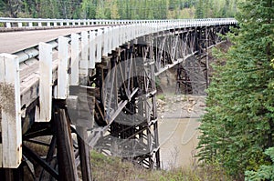
Unique as it was, a major drawback appeared as the region developed and oil and gas companies sent heavier trucks into the area: the bridge could only handle loads under 25 tonnes. Trucks over that weight had to ford the river; therefore, the new bridge was built in 1978. The old bridge remains on a former alignment of the highway.
In the postwar years, trucks with loads that exceeded the bridge’s maximum 25-tonne capacity had to avoid the bridge and ford the river instead. This proved especially inconvenient for the expanding oil and gas industry and, in 1978, a new road was built that bypassed the bridge and, so secured its survival. Kiskatinaw Provincial Park provides access to the river and interesting views of the bridge's structure.
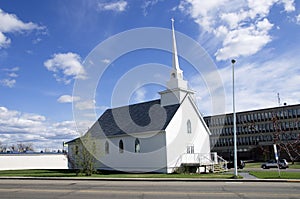
Kiskatinaw Provincial Park Old Alaska Highway Historic Milepost 21
The campsites are large and well spaced in a mixed forest.
Approximately 35 km north of Dawson Creek on Highway 97 turn east onto the Old Alaska Highway. Follow the road for approximately 2.5 km where there is a fork in the road and follow the road to the left until you reach the campground.
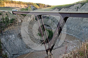
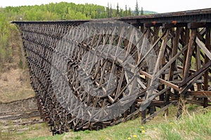
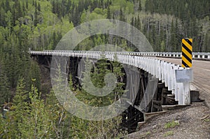
This three-span timber truss bridge has an amazing nine-degree curve along its 162.5 m (534 foot) length – a curve that US PRA engineers designed to accommodate the highway’s hairpin curve. At the time, it was the first wooden curved bridge to be built in Canada.
In addition to the challenge of building a significant curve into a wooden bridge, the US PRA had to contend with assembling masses of materials, shipping delays, floods and unusual temperatures – all of which extended the construction time to nine months. About 500,000 board feet of creosoted British Columbia fir had to be shipped from the coast. Gravel had to be hauled 16 km in from a Peace River crushing plant. An unseasonal cold snap halted the curing of the cement poured to create the bridge’s pedestals and piers, which meant the construction crew had to prevent the curing concrete from freezing. They did this by enclosing the concrete and keeping it to a temperature of 22°C (72°F) for 10 days. This was extremely difficult given that the work involved almost 610 cubic m (800 cubic yards) of concrete.
In addition to the challenge of building a significant curve into a wooden bridge, the US PRA had to contend with assembling masses of materials, shipping delays, floods and unusual temperatures – all of which extended the construction time to nine months. About 500,000 board feet of creosoted British Columbia fir had to be shipped from the coast. Gravel had to be hauled 16 km in from a Peace River crushing plant. An unseasonal cold snap halted the curing of the cement poured to create the bridge’s pedestals and piers, which meant the construction crew had to prevent the curing concrete from freezing. They did this by enclosing the concrete and keeping it to a temperature of 22°C (72°F) for 10 days. This was extremely difficult given that the work involved almost 610 cubic m (800 cubic yards) of concrete.
There are two bridges in this area: the new Kiskatinaw Bridge (opened fall 1978) and the original Kiskatinaw Bridge, also known as the Historic Kiskatinaw Curved Bridge (built 1942-43). The historic bridge, located just north of Dawson Creek, British Columbia, is the only original timber bridge built by the US Public Roads Administration (PRA) that is still in use.
Alaska Highway Historic Milepost 21 Kiskatinaw Bridge/Wallace A. MacKey Ltd
The task of the United States Army Corps of Engineers was to build a pioneer road for military traffic from Dawson Creek to Big Delta, Alaska. This meant fording rivers and creeks in the most expedient, if not permanent, way possible. The responsibility for creating a more durable, all season highway fell to civilian contractors who followed closely behind the troops and were coordinated by the United States Public Roads Administration.
Though there were many timber bridges built by these civilian workers, the Kiskatinaw Bridge is the only one still in use. It is also one of the most unusual, curving nine degrees along its 162.5 metre (534 foot) length.
The bridge, the first of its kind in Canada, was built in 1942-43 by Dow Construction of Toronto. Cement footings were put in place in November 1942 using gravel hauled 26 kilometres (16 miles) from a crushing plant at the Peace River. An extreme cold snap that month made it necessary to enclose all concrete pedestals and piers and keep them heated to 22 degrees celsius (72 degrees fahrenheit) for 10 days. This was no mean feat given that the work involved almost 610 cubic metres (800 cubic yards) of concrete.
The bridge is a three span, timber truss structure built 30 metres (100 feet) above the stream. Approximately 500,000 board feet of creosoted British Columbia fir were used in its construction. The fir was shipped from coastal B.C. to the railhead at Dawson Creek. It should have arrived in early 1943, well before spring thaw, but was not delivered until April. Breakup made for a tough haul through the mud from Dawson Creek. Further construction delays occurred when the temporary log bridge and much of the scaffolding were damaged by spring runoff that year and had to be replaced.
Historic Mile 2 Cantel Repeater Station
Cantel telephone-teletype lines were streached from Alberta to Fairbanks, Alaska, making it one of the world's longest open wire toll circuits at the time.
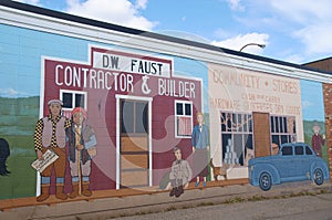
Walter Wright Pioneer Village Museum and Rotary Lake
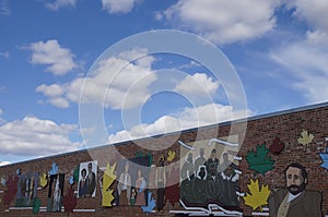
Growth slowed in the 1960s, with the population reaching its all-time high in 1966. In the 1970s, the provincial government moved its regional offices from Pouce Coupe to the city, Northern Lights College opened a Dawson Creek campus, and the Dawson Creek Mall was constructed. Several modern grain elevators were built, and the town's five wooden grain elevators, nicknamed "Elevator Row", were taken out of service. Only one of the historic elevators remains, converted to an art gallery. Since the 1970s, with the nearby town of Fort St. John attracting much of the area's industrial development and Grande Prairie becoming a commercial hub, the town's population and economy have not significantly increased.
Dawson Creek is named after the watercourse of the same name, itself named after who led a surveying team through the area in August 1879; a member of the team labelled the creek with Dawson's name. The community that formed by the creek was one of many farming communities established by European-Canadian settlers moving west through the Peace River Country. When the Canadian government began issuing homestead grants to settlers in 1912, the pace of migration increased. With the opening of a few stores and hotels in 1919 and the incorporation of the Dawson Creek Co-operative Union on 28 May 1921, Dawson Creek became a dominant business centre in the area. After much speculation by land owners and investors, the Northern Alberta Railways built its western terminus 3 km (2 mi) from Dawson Creek. The golden spike was driven on 29 December 1930, and the first passenger train arrived on 15 January 1931. The arrival of the railway and the construction of grain elevators attracted more settlers and business to the settlement. The need to provide services for the rapidly growing community led Dawson Creek to incorporate as a village in May 1936. A small wave of refugees from the Sudetenland settled in the area in 1939 as World War II was beginning. The community exceeded 500 people in 1941.
By 1951, Dawson Creek had more than 3,500 residents. In 1952, the John Hart Highway linked the town to the rest of the British Columbia Interior and Lower Mainland through the Rocky Mountains; a new southbound route, known locally as Tupper Highway, made the town a crossroads with neighbouring Alberta. The next year, western Canada's largest propane gas plant was built and federal government offices were established in town. In 1958, the extension of the Pacific Great Eastern Railway to the Peace from Prince George was completed, and the village was re-incorporated as a city. Between 1951 and 1961, the population of Dawson Creek more than tripled.
Since 1992, the city has undergone several boundary expansions. One expansion incorporated undeveloped land in the southeast for an industrial park and a Louisiana-Pacific Canadaveneer factory. The city extended sewer and water lines to the location; however, the area was not developed and with the factory only half-built, L-P Canada abandoned its plans. A business making manufactured homes bought the factory and completed its development in 2005. Another expansion incorporated the existing oriented strand board factory in the northwest corner of the city, while further incorporations have included undeveloped land to the south and north.
Growth slowed in the 1960s, with the population reaching its all-time high in 1966. In the 1970s, the provincial government moved its regional offices from Pouce Coupe to the city, Northern Lights College opened a Dawson Creek campus, and the Dawson Creek Mall was constructed. Several modern grain elevators were built, and the town's five wooden grain elevators, nicknamed "Elevator Row", were taken out of service. Only one of the historic elevators remains, converted to an art gallery. Since the 1970s, with the nearby town of Fort St. John attracting much of the area's industrial development and Grande Prairie becoming a commercial hub, the town's population and economy have not significantly increased.
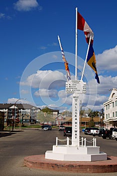
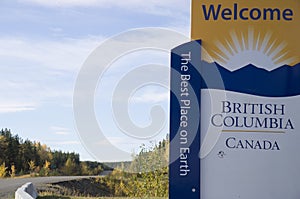
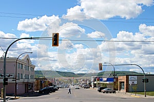
Dawson Creek is located in the dry and windy prairie land of the Peace River Country. As the seat of the Peace River Regional District and a service centre for the rural areas south of the Peace River, the city has been called the "Capital of the Peace". It is also known as the "Mile 0 City", referring to its location at the southern end of the Alaska Highway. It also has a heritage interpretation village, an art gallery, and a museum. Annual events include a fall fair and rodeo.
Start of the Alaska Highway Visitor Centre
History
Upon entering the war, the United States decided to build a transportation corridor to connect the US mainland to Alaska. In 1942, thousands of US Army personnel, engineers, and contractors poured into the city – the terminal of rail transport – to construct the Alaska Highway. The highway was completed in less than a year; even after the workers involved in its construction departed, population and economic growth continued. In February 1943, a major fire and explosion in a livery barn, packed with road-building supplies including dynamite, caused serious damage to the center of town; five people were killed and 150 injured.
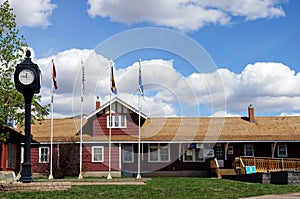
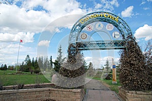
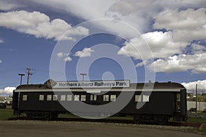
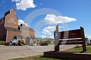
Northern Alberta Railways Park in the heart of the city hosts the Visitor Centre, the Railway Station Museum, a northern wildlife display, the local art gallery, the Mile 0 Cairn, 2 gift shops, public washrooms and plenty of large vehicle parking.
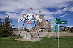
Historic Mile 0, Dawson Creek, British Columbia, Canada
Dawson Creek is a city in northeastern British Columbia, Canada. The municipality of 24.37 square kilometres (9.41 sq mi) had a population of 11,583 in 2011. Dawson Creek derives its name from the creek of the same name that runs through the community. The creek was named after George Mercer Dawson by a member of his land survey team when they passed through the area in August 1879. Once a small farming community, Dawson Creek became a regional centre when the western terminus of the Northern Alberta Railways was extended there in 1932. The community grew rapidly in 1942 as the US Army used the rail terminus as a transshipment point during construction of the Alaska Highway. In the 1950s, the city was connected to the interior of British Columbia via a highway and railway through the Rocky Mountains. Since the 1960s, growth has slowed.
Dawson Creek is located in the dry and windy prairie land of the Peace River Country. As the seat of the Peace River Regional District and a service centre for the rural areas south of the Peace River, the city has been called the "Capital of the Peace". It is also known as the "Mile 0 City", referring to its location at the southern end of the Alaska Highway. It also has a heritage interpretation village, an art gallery, and a museum. Annual events include a fall fair and rodeo.
Start of the Alaska Highway Visitor Centre
Become a image contributor at Dreamstime (as your stock photography agent) and start selling your camera and/or cell phone travel and other images. Learn how by clicking on a banner above.
In 1942 the USA and Canada united for a cause. After the Japanese attack on Pearl Harbor, fear paralyzed North America. FDR, concerned about an invasion of Alaska, dusted off a decades old idea to build a road to the Alaskan interior. Ref.
In the spring of 1942, "the End Of Steel" became a major terminus for troops, supplies, and equipment arriving from Edmondton and destined for the north.
In the spring of 1942, "the End Of Steel" became a major terminus for troops, supplies, and equipment arriving from Edmondton and destined for the north.
Northern Alberta Railways Park in the heart of the city hosts the Visitor Centre, the Railway Station Museum, a northern wildlife display, the local art gallery, the Mile 0 Cairn, 2 gift shops, public washrooms and plenty of large vehicle parking.
The city is named after George Mercer Dawson (as is Dawson City, Yukon): a 19th century railroad surveyor, geologist and anthropologist who was one of the very first white men to travel through the area.
Historic Mile 0 Dawson Creek, British Columbia/start of the Alaska Highway, Dawson Creek Flight Strip, Public Roads Administration, R. Melville Smith Camp, U.S. Engineers Camp, M.H.K.C.B. Construction Company Camp, Area No 1 & 2 Army Camp, Dowell Construction Company Camp, U.S.Q.M.C, Headquarters Alaska Highway.
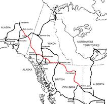
The Alaska Highway Dawson Creek, British Columbia to Delta Junction, Alaska (historical routes, heritage sites, sightseeing, driving tour) Pioneer Road - Contract Road - Public Road
Become a image contributor at Dreamstime (as your stock photography agent) and start selling your camera and/or cell phone travel and other images. Learn how by clicking on a banner above.