Alaska Storyteller Photography

© Robert M. Braley Jr., Photographer


Home

United States

Alabama

Alaska

Anchor Point

Anchorage

Alaska Flag

Alaska Natives

Big Lake

Chicken

Chickaloon

Chugiak

Copper Center

Cold Bay

Cooper Landing

Cordova

Cottonwood Creek

Civil War Alaska

Delta Junction

Denali Park

Elmendorf AFB

Eureka

Fairbanks

Glennallen

Hatchers Pass

Healy

Houston

Homer

Hope

Hyder

Kenai

King Cove

Kodiak

Lake Louise

Nenana

Ninilchik

North Pole

Northway Junction

Palmer

Rabbit Slough

Richardson Highway

Russian America

Sand Point

Seward

Sitka

Soldotna

Sterling

Talkeetna

Tok

Tok Cut-Off

Trapper Creek

Captian Cook

Southeast

Swan Lake

Valdez

Wasilla

Willow

Yakutat

Alaska Highway

Alaska Highway 2

Alaska Highway 3

Alaska Highway 4

Alaska Highway 5

Alaska Highway 6

Alaska Highway 7

Alaska Highway 8

Alaska Highway 9

Alaska Highway 10

Alaska Highway 11

Alaska Highway 12

Alaska Highway 13

Historic Mileposts

Historic Mile 941

Historic Mile 1010

Historic Mile 1016

Historic Mile 1067

Historic Mile 1072

Historic Mile 1083

Historic Mile 1093

Historic Mile 1152

Historic Mile 1164

Historic Mile 1188

Historic Mile 1202

Historic Mile 1229

Historic Mile 1221

Historic Mile 1225

Historic Mile 1249

Historic Mile 1254

Historic Mile 1257

Historic Mile 1264

Historic Mile 1306

Historic Mile 1309

Historic Mile 1314

Historic Mile 1332

Historic Mile 1422

Arkansas

Arizona

California

Bakersfield

Fort Crook Museum

George AFB

Klamath AFS

Klamath WWII Radar

Redwood NP

San Francisco

Samohi

Santa Monica

Venice

Whiskeytown

Colorado

Connecticut

Delaware

Florida

Georgia

Hawaii

Pearl Harbor

Kansas

Kentucky

Idaho

Idaho City

Illinois

Indiana

Louisiana

Iowa

Ohio

Oregon

Ashland

Lithia Park

Oregon Coast

Maine

Maryland

Massachusetts

Michigan

Minnesota

Mississippi

Missouri

Montana

Nebraska

Nevada

New Hampshire

New Jersey

New York

New Mexico

Ruidoso

North Carolina

North Dakota

Oklahoma

Pennsylvania

Rhode Island

South Carolina

South Dakota

Tennessee

Texas

Utah

Vermont

Virginia

Washington

Anacorties

Anacortes WA

Centralia WA

Chehalis WA

Elbe WA

Lewis County WA

Mt Rainer

Olympia WA

Steilacoom WA

Tacoma

Washington D.C.

Wisconsin

West Virginia

Wyoming

Canada

British Columbia

100 Mile House

108 Mile House

Hope BC

Stewart BC

Chetwynd

Hudsons Hope

Pouce Coupe BC

Dawson Creek AH0000

Taylor AH0035

Fort St John AH0047

WonOWon AH0101

Pink Mountain AH0143

Fort Nelson AH0300

Tetsa River AH0375

Toad River AH0422

Summit Lake 0392

Muncho Lake AH0456

Liard Hot Springs AH0496

Smith River AH0514

Contact Creek AH0588

BC Border AH 0627

Dawson Creek VC

Dawson Creek DT

Yukon

Yukon Border AH0627

Watson Lake AH0635

Cassiar Hwy AW0649

Nugget City AH0650

Rancheria River AH0710

Cont Divide Lodge AH0721

Swift River AH0733

Teslin AH0604

Johnsons Crossing AH0836

Marsh Lake AH0890

Whitehorse AH0905

Whitehorse AH0915

Canyon Creek AH0941

Beaver Creek

Crete

Equator

Israel

Products

Nature

Animals

Flowers

Landscapes

Sunset

Wildflowers

Wildlife

Fish

Birds

Albatrosses

Canada Goose

Comorants

CaracarasFalcons

DucksGeeseSwans

Frigatebirds

Grebes

Loons

Osprey

PartridgesGrouse

Pelicans

redwingedblackbird1

HawksKitesEagles

ShearwatersPetrels

StormPetrels

Bats

Vultures

Mammals

Black Bear

bison

BitternsHeronsEgr

Caribou

Carnivorans

Cetaceans

Dall Sheep

Deer

Moose

Mountain Goat

Seals Sea Lions Walrus

Orca

Pikas Hares Rabbits

Polar Bear

Primates

Raccoons

Rodents

Great blue heron

Shrews

Bears

Beaver

Ungulates

Weasels

Military

C-17

T-6G

T-33

P-51 Mustang

KC-135

HH-60

F-86

F-80

C-47

HC-130N

C-130H

C-130E

C-123J

Alaska National Guard

Alaska Air National Guard

Camp Murray

Alaskanized

Ladd AFB

AKNG Museum

U-Tapao

Pixels

links

About

Policy/Copyright

Contact

Photo Sizes

Welcome to Alaska


Become a image contributor at Dreamstime (as your stock photography agent) and start selling your camera and/or cell phone travel and other images. Learn how by clicking on a banner above.

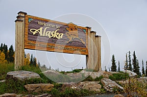
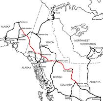
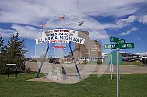
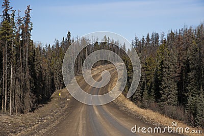
The Alaska Highway
Dawson Creek, British Columbia to Delta Junction, Alaska
(historical routes, heritage sites, sightseeing, driving tour)
Pioneer Road - Contract Road - Public Road

Alaska Highway Sign
Alaska Highway Historic Mile 0

Pink Mountain, British Columbia
Historic Mile 143

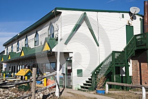
Historical Mile 143: PINK MOUNTAIN (pop. 99). Sunrise at Pink Mountain is spectacular and a must see and photograph.

Pink Mountain is an unincorporated community in British Columbia, Canada. Nestled in the Rocky Mountain foothills, the town is located 113 miles (180 km) NW of Fort St. John and 140 miles (224 km) NW of Dawson Creek, on Mile 143 of the Alaska Highway. Approximately 100 people inhabit the community.

Sasquach Crossing Alaska Highway
Alaska Highway Historic Mile 143

 
Only part of the mountain itself, aptly named after the pinkish burnt rock seams which it is locally famed for, has been designated provincial park status. Located 10 miles (16 km) south-west of Mile 147, Pink Mountain Provincial Park is one of the region's designated areas for wildlife. However, because much of the park area is on a fairly steep slope, it is only sparsely covered with vegetation and is not suitable butterfly habitat. Prime butterfly habitat for the rare arctic butterflies in the southernmost part of their range is threatened by the proposed development of a wind farm with its large concrete footprint. The park’s primary role is to protect a significant palaeontological site containing examples of large marine fossils from the Mesozoic Era, including the largest ichthyosaur ever discovered.

Pink Mountain is also the only place in the British Columbia where wild plains bison roam. The 1000 plus bison found roaming the area are not naturally occurring, but rather descendants of an escaped herd of 50 from those imported by local guide and outfitter R. Lynn Ross in 1968.

Suicide Hill
Historic Mile 148

Alaska Highway Canada Suicide Trail
Looking north up Suicide Hill
Alaska Highway Historic Mile 148

Historic Mile 148 Suicide Hill is one of the most treacherous hills on the original highway noted for its ominous greeting: PREPARE TO MEET THY MAKER.

Remote Road Alaska Highway Canada
Alaska Highway Historic Mile 148

Remote Road Alaska Highway Canada
Looking north up the old highway toward Suicide Hill
Alaska Highway Historic Mile 148

Buckinghorse River
Alaska Highway Historic Milepost 175

Buckinghorse River Wayside Provincial Park
Alaska Highway Historic Milepost 175


The campsites are on gravel right next to one another except for one secluded site. Most of the sites have river views.

Located approximately 200 km northwest of Fort St. John at kilometre 278 of the Alaska Highway (Highway 97).

  • Operator or sponsor is: BC Parks
  • Nearby town or city: Fort St. John
  • Total campsites: 33
  • Unserviced campsites: 33
  • Tables provided at campsites
  • Pump water available
  • Water should be boiled
  • Pit toilets
  • Wheelchair access
  • Boat launch

Historic Mile 191 - Trutch Mountain Summit (Elevation 4,134 feet)
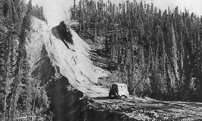
The second highest summit on the original highway. Completed in 1987, the bypass route curcumvented the mountain, eliminating the steep, winding climb to the top.

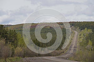
Historic Mile 234 Adsett Creek Highway Realignment: Completed in 1992, this major rerouting eliminated 132 curves on the stretch of highway that originally ran between Miles 234 and 275.

More information and photo's at CampScout.com

Website powered by Network Solutions®