I have 10,000+ images available for sale. Type any search word into the search engine block to find out something you are looking for. Type in the name of the webpage your on to view photo's for that page.
Cordova (/kɔːrˈdoʊvə,ˈkɔːrdəvə/) is a city in Chugach Census Area, Alaska, United States. It lies near the mouth of the Copper River, at the head of Orca Inlet on the east side of Prince William Sound. The population was 2,239 at the 2010 census, down from 2,454 in 2000. Cordova was named Puerto Cordova by Spanish explorer Salvador Fidalgo in 1790. No roads connect Cordova to other Alaskan communities, so a plane or ferry is required to travel there. In the Exxon Valdez oil spill of March 1989, an oil tanker ran aground northwest of Cordova, heavily damaging ecology and fishing. It was cleaned up shortly after, but there are lingering effects, such as a lowered population of some birds.
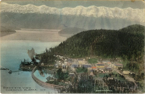
Postcard Cordova, Alaska. Public Domain
History
Cordova, Alaska Jan 26, 1907 Public Domain Photo
In 1790 the inlet in front of the current Cordova townsite was named Puerto Cordova by Spanish explorer Salvador Fidalgo, after Spanish admiral Luis de Córdova y Córdova. The city of Cordova was named after it, although the inlet itself was later renamed the Orca Inlet. Cordova proper was founded as a result of the discovery of high-grade copper ore at Kennecott, north of Cordova. A group of surveyors from Valdez laid out a town site and Michael James Heney purchased half the land for the terminus of the Copper River and Northwestern Railway after determining that the neighboring town of Katalla was a poor harbor. Heney and his crew held a brief ceremony to organize the town on March 26, 1906. A week later crews arrived to
begin work on the railroad. The first lots in the new town site, which make up the heart of present-day Cordova, were sold at auction in May 1908. As the railroad grew, so did the town. Eventually schools, businesses, a hospital, and utilities were established. After the railroad was completed Cordova became the transportation hub for the ore coming out of Kennecott. In the years 1911 to 1938, more than 200 million tons of copper ore was transported through Cordova.
The area around Cordova was historically home to the Eyak, with a population of Chugach to the west, and occasional visits from Ahtna and Tlingit people for trade or battle. The last full-blooded Eyak Marie Smith Jones died in 2008, but the native traditions and lifestyle still has an influence on the local culture. Cordova was also once the home of a booming razor clam industry, and between 1916 and the late 1950s it was known as the "Razor Clam Capital of the World". Commercial harvest in the area was as much as 3.5 million pounds. Returns began declining in the late 1950s, presumably due to overharvesting and a large die-off in 1958. The 1964 Good Friday earthquake effectively and completely obliterated the industry; in some areas, the ground was thrust up by as much as six feet, exposing the already depleted clam beds. There has been no commercial harvest in the area since 1988 with the exception of a brief harvest in 1993.
Advertisment Links to Dreamstime My RF Stock Agent Profile
History
July 16 thru August 20, 1741, Danish explorer Vitus Bering and Chirikov, who was working for Russia, landed a small party on an island near Prince William Sound, thus discovering Alaska. http://akstp.com/alaskatimeline.html
1778, Captain James Cook made his famous voyage to Alaska and drew detailed maps of the area, naming such landmarks as Mount St. Augustine, Montague Island, Prince William Sound, Turnagain Arm and Cape Elizabeth. http://akstp.com/alaskatimeline.html
February 14, 1779, Captain James Cook was killed by Hawaiians in a dispute over the theft of a cutter. http://akstp.com/alaskatimeline.html
1783 - Russian discovery of the mouth of the Copper River.
1790 - Lt. Salvador Fidalgo, a Spanish cartographer, anchors near Hinchinbrook Island. He officially names the inlet Puerto de Cordova.
1791 - Fort Constantine is established a Nuchek. The Russian trading post deals mainly in the Asian and European sea otter fur trade.
1798-1799 - The Russian Promyshlenaik Potochkin leads first expedition up Copper River to the mouth of the Chitina River.
1863 - The Russian-American Company rejects proposal to search for copper and gold in the Copper River area: it remains focused on the fur trade.
1884 - Lt. William Abercrombie of the U.S. Army explories the Copper River as far as the Abercrombie Rapids.
1885 - Lt. Henry Allen explories the Copper River, develops good relations with the Ahtna at Taral and notes extensive use of copper tools.
1887 - Odiak Cannery built on Odiak Slough by Captain Sands.
1888 - Captain O.J. Humphrey builds the Pacific Steam Whaling Company cannery.
1890 - Odiak becomes a thriving town of 200 people and is renamed Eyak. Natives at the nearby traditional village of the same name relocate to the new town to be near cannery work.
1892 - Village of Alaganik is abandoned following a major epidemic.
1895 - Pacific Steam Whaling Company relocates cannery to Orca. Remaining cannery at Odiak is abandoned.
1896 - Gold is discovered on the Klondike, which leads to development of mining and transportation from Prince William Sound to the Interior of Alaska. The Ahtna people - Athabaskan speakers who were the sole masters of resources and trade in the Copper River area - are severely disrupted by the influx of prospectors.
1899 - The Ahina are under great stress. In exchange for a cache of food, Chief Nicolai leads prospector Ed Gates and his partners to the copper source.
1900 - Clarence Warner and "Tarantula Jack" Smith stake the Bonanza mine outcrop and much of the land that would become the Kennecott mines. Stephen Birch, a young mining engineer, aquires options on the claim.
1901-1904 - Backed by a New York investor, Birch forms the Alaska Copper and Coal Company, which is promptly sued by others claiming ownership of the rich deposit.
1905 - The Alaska Copper and Coal Company reorganizes as the Kennecott Mines Company. The Guggenheim family - controllers of the American Smelting and Refining Company - and J.P. Morgan organize the "Alaska Syndicate" to fund the mine's, development. Plans include building a railroad from tidewater to the copper mines up the Copper and Chitina River Valley's developing the Bering River coal deposits just to the east of the mouth of the Copper River and building a smelter on the Copper River Delta. Railroad promoters select Valdez and Katalla as competing routes into the Interior.
1905 - White Pass and Yukon Railroad builder Michael J. Heney selects Eyak as the starting point for a new railway.
1906 - The syndicate begins railhead construction at Katalla prior to securing right-of-way to the copper deposits. Mike Heney files for right-of-way up the Copper River. The syndicate is forced to buy Heney's Abercrombie Canyon right-of-way for $250,000.00 and construction from Katalla to the Kennecott mines resumes.
1906 - Heney begins construction of the Copper River and Northwest Railway. A business district develops near the headquaters in Eyak. A land shortage becomes apparent. In November, President Roosevelt closes the Bering River coal fields and a huge winter storm destroys the Katalla sea wall, dooming the site as a reliable port.
1907 - The Alaska Syndicate abandons the Katalla terminus and hires Heney as general contractor for constructing the railroad.
1908 - Lots are plotted in the area where Cordova's current business district stands.
July 8, 1909 - Cordova is incorporated.
March 29, 1911, Copper River Railway is completed. Copper spike is driven at Kennecott Mine.
April 8, 1911 - The first shipment of copper ore, worth $250,000.00, is made.
1910-1915 - Cordova serves as the supply point for Kennecott and other mines in the Copper River and Chitina drainage. Commerical fishing continues to play a role in the local economy.
1917 - Pioneer Packing Company builds the first cannery on Cordova's waterfront.
1920 - The City of Cordova constructs a warf to support small boats associated with the canneries that now line the railroad tracks on the waterfront.
1937 - Five canneries are operating in the Cordova area.
November 11, 1938 - Kennecott Mines shut down.
1935-1940 - U.S. Army occupies the Copper River and Northwest Railroad right-of-way from Cordova to mile 13, where the Civilian Aeronautics Administration (CAA) operates an air base.
1945 - Kennecott Corporation, formally turns over the right-of-way to the Territory of Alaska. Near Cordova, the U.S. Forest Services pulls up the rails and builds a road to the airport at mile 13. The military proposes the first plans to convert the railway to a road connecting Cordova to the rest of Alaska's road system.
1953 - The federal government appropriates $500,000.00 to begin construction of a road from Cordova north to Chitina.
1954 - Congress appropriates another $2,400,000.00. Construction continues thrpough the 1950s and early 1960s to mile 70 on the old railway right-of-way.
1961 - Alaska Department of Highway paves the Million Dollar Bridge and begins to tear up the rails from Chitina to Kennecott and ship them to Japan.
1964 - A major earthquake, centered 90 miles west of the railroad, damages the grade, the bridge and the causeways and the bridges over the delta.
1970s - The State of Alaska replaces bridges on the Copper River Delta and installs a ramp to facilitate crossing the collapsed section of the Million Dollar Bridge.
1980s - Commerical fishing thrives in Cordova.
March 24, 1989 - The Exxon Valdez spills at least 11 million gallons of North Slope crude oil into Prince William Sound. Cordova residents and fishermen unite in massive clean-up efforts.
1990s - Fishermen rebuild the commerical fishing industry and the debate continues over whether or not Cordivans want to be on the road system.