I have 10,000+ images available for sale. Type any search word into the search engine block to find out something you are looking for. Type in the name of the webpage your on to view photo's for that page.
Denali National Park and Preserve, formerly known as Mount McKinley National Park, is an American national park and preserve located in Interior Alaska, centered on Denali, the highest mountain in North America. The park and contiguous preserve encompass 6,045,153 acres (9,446 sq mi; 24,464 km2) which is larger than the state of New Hampshire.[3] On December 2, 1980, 2,146,580-acre (3,354 sq mi; 8,687 km2) Denali Wilderness was established within the park. Denali's landscape is a mix of forest at the lowest elevations, including deciduous taiga, with tundra at middle elevations, and glaciers, snow, and bare rock at the highest elevations. The longest glacier is the Kahiltna Glacier. Wintertime activities include dog sledding, cross-country skiing, and snowmobiling. The park received 594,660 recreational visitors in 2018.
Prehistory and protohistory
Human habitation in the Denali Region extends to more than 11,000 years before the present, with documented sites just outside park boundaries dated to more than 8,000 years before present. However, relatively few archaeological sites have been documented within the park boundaries, owing to the region's high elevation, with harsh winter conditions and scarce resources compared to lower elevations in the area. The oldest site within park boundaries is the Teklanika River site, dated to about 7130 BC. More than 84 archaeological sites have been documented within the park. The sites are typically characterized as hunting camps rather than settlements, and provide little cultural context. The presence of Athabaskan peoples in the region is dated to 1,500 - 1,000 years before present on linguistic and archaeological evidence, while researchers have proposed that Athabaskans may have inhabited the area for thousands of years before then. The principal groups in the park area in the last 500 years include the Koyukon, Tanana and Dena'ina people.
Establishment of the park
In 1906, conservationist Charles Alexander Sheldon conceived the idea of preserving the Denali region as a national park. He presented the plan to his co-members of the Boone and Crockett Club. They decided that the political climate at the time was unfavorable for congressional action, and that the best hope of success rested on the approval and support from the Alaskans themselves. Sheldon wrote, "The first step was to secure the approval and cooperation of the delegate who represented Alaska in Congress."[citation needed]
In October 1915, Sheldon took up the matter with Dr. E. W. Nelson of the Biological Survey at Washington, D.C. and with George Bird Grinnell, with a purpose to introduce a suitable bill in the coming session of Congress. The matter was then taken to the Game Committee of the Boone and Crockett Club and, after a full discussion, it received the committee's full endorsement.
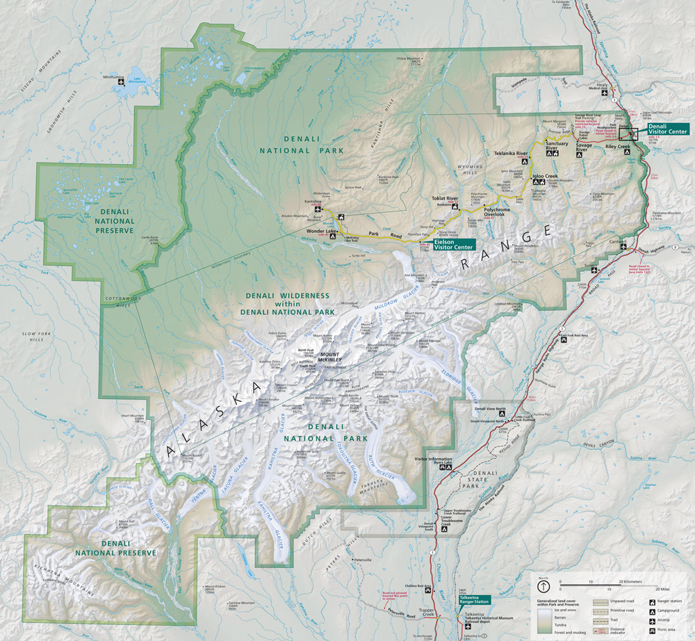
Denali National Park map NPS Public Domain Photo
On December 3, 1915, the plan was presented to Alaska's delegate, James Wickersham, who after some deliberation gave his approval. The plan then went to the Executive Committee of the Boone and Crockett Club and, on December 15, 1915, it was unanimously accepted. The plan was thereupon endorsed by the Club and presented to Stephen Mather, Assistant Secretary of the Interior in Washington, D.C., who immediately approved it.
The bill was introduced in April 1916, by Delegate Wickersham in the House and by Senator Key Pittman of Nevada in the Senate. Much lobbying took place over the following year, and on February 19, 1917, the bill passed. On February 26, 1917, 11 years from its conception, the bill was signed in legislation by the President of the United States, Woodrow Wilson, thereby creating Mount McKinley National Park.[5][6]
A portion of Denali, excluding the summit, was included the original park boundary. The boundary was expanded in 1922 and again in 1932[7] and 1947 to include the area of the hotel and railroad.
On Thanksgiving Day in 1921, the Mount McKinley Park Hotel opened. In July 1923, President Warren Harding stopped at the hotel, on a tour of the length of the Alaska Railroad, during which he drove a golden spike signaling its completion at Nenana.[citation needed] The hotel was the first thing visitors saw stepping down from the train. The flat-roofed, two-story log building featured exposed balconies, glass windows, and electric lights. Inside were two dozen guest rooms, a shop, lunch counter, kitchen, and storeroom. By the 1930s, there were reports of lice, dirty linen, drafty rooms, and marginal food, which led to the hotel eventually closing.[citation needed] After being abandoned for many years, the hotel was destroyed in 1972 by a fire.
The 93 mi (150 km) Park Road was completed in 1938 after 17 years of construction.
There was no road access to the park entrance until 1957, when the Denali Highway opened; park attendance greatly expanded: there were 5,000 visitors in 1956 and 25,000 visitors by 1958. In 1971, the George Parks Highway, under piecemeal construction for several years, was completed, providing direct highway connections to Anchorage and Fairbanks. Visitation doubed to 88,000 from 1971 to 1972.
The name of Mount McKinley National Park was subject to local criticism from the beginning of the park. The word Denali means "the high one" in the native Athabaskan language and refers to the mountain itself. The mountain was named after newly elected US president William McKinley in 1897 by local prospector William A. Dickey. The United States government formally adopted the name Mount McKinley after President Wilson signed the bill creating Mount McKinley National Park into effect in 1917.[9] In 1980, Mount McKinley National Park was combined with Denali National Monument, and the Alaska National Interest Lands Conservation Act named the combined unit the Denali National Park and Preserve. At that time the Alaska state Board of Geographic Names changed the name of the mountain to Denali. However, the U.S. Board on Geographic Names did not recognize the change and continued to denote the official name as Mount McKinley. This situation lasted until Aug. 30, 2015, when President Barack Obama directed Secretary of the InteriorSally Jewell to rename the mountain to Denali, using statutory authority to act on requests when the Board of Geographic Names does not do so in a "reasonable" time period
1990s
In 1992, Christopher McCandless ventured into the Alaskan wilderness and settled in an abandoned bus in the park on the Stampede Trail at 63°52′5.96″N149°46′8.39″W , near Lake Wentitika. He carried little food or equipment, and hoped to live simply for a time in solitude. Almost four months later, McCandless' starved remains were found, weighing only 67 pounds (30 kg).[citation needed] His story has been widely publicized via articles, books, and films, and the bus where his remains were found has become a shrine attracting people from around the world.[11]
On September 24, 2020, the Museum of The North[12] at the University of Alaska (Fairbanks) announced it became the permanent home of McCandless' 'Magic Bus 142' where it will be restored and an outdoor exhibit will be created.
2000s
On November 5, 2012, the United States Mint released the 15th of its America the Beautiful Quarters series, which honors Denali National Park. The coin's reverse side features a Dall sheep with Denali in the background.[14]
In September 2013, President Barack Obama signed the Denali National Park Improvement Act into law. [15] The statute allows the United States Department of the Interior to "issue permits for microhydroelectric projects in the Kantishna Hills area of the Denali National Park and Preserve in Alaska"; it authorizes the Department of the Interior and a company called Doyon Tourism, Inc. to exchange some land in the area; it authorizes the National Park Service (NPS) to "issue permits to construct a natural gas pipeline in the Denali National Park"; and it renames the existing Talkeetna Ranger Station the Walter Harper Talkeetna Ranger Station.[16] The National Parks Conservation Association supported the bill because the legislation "takes a thoughtful approach to protecting roadless Alaska, promoting renewable energy development, and honoring native Alaskans.
The park is undeveloped wilderness with the exception of the two day-use areas, three campgrounds, and two trailheads accessible from the Parks Highway.[1]