Alaska Storyteller Photography

© Robert M. Braley Jr., Photographer


Home

United States

Alabama

Alaska

Anchor Point

Anchorage

Alaska Flag

Alaska Natives

Big Lake

Chicken

Chickaloon

Chugiak

Copper Center

Cold Bay

Cooper Landing

Cordova

Cottonwood Creek

Civil War Alaska

Delta Junction

Denali Park

Elmendorf AFB

Eureka

Fairbanks

Glennallen

Hatchers Pass

Healy

Houston

Homer

Hope

Hyder

Kenai

King Cove

Kodiak

Lake Louise

Nenana

Ninilchik

North Pole

Northway Junction

Palmer

Rabbit Slough

Richardson Highway

Russian America

Sand Point

Seward

Sitka

Soldotna

Sterling

Talkeetna

Tok

Tok Cut-Off

Trapper Creek

Captian Cook

Southeast

Swan Lake

Valdez

Wasilla

Willow

Yakutat

Alaska Highway

Alaska Highway 1

Alaska Highway 2

Alaska Highway 3

Alaska Highway 4

Alaska Highway 5

Alaska Highway 6

Alaska Highway 7

Alaska Highway 8

Alaska Highway 9

Alaska Highway 10

Alaska Highway 11

Alaska Highway 12

Alaska Highway 13

Historic Mileposts

Historic Mile 0

Historic Mile 2

Historic Mile 21

Historic Mile 35

Historic Mile 47

Historic Mile 49

Historic Mile 52

Historic Mile 73

Historic Mile 90

Historic Mile 101

Historic Mile 143

Historic Mile 148

Historic Mile 175

Historic Mile 191

Historic Mile 234

Historic Mile 300

Historic Mile 375

Historic Mile 392

Historic Mile 422

Historic Mile 456

Historic Mile 496

Historic Mile 514

Historic Mile 588

Historic Mile 627

Historic Mile 635

Historic Mile 649

Historic Mile 650

Historic Mile 710

Historic Mile 721

Historic Mile 733

Historic Mile 797

Historic Mile 836

Historic Mile 804

Historic Mile 905

Historic Mile 906

Historic Mile 890

Historic Mile 915

Historic Mile 941

Historic Mile 1010

Historic Mile 1016

Historic Mile 1067

Historic Mile 1072

Historic Mile 1083

Historic Mile 1093

Historic Mile 1152

Historic Mile 1164

Historic Mile 1188

Historic Mile 1202

Historic Mile 1229

Historic Mile 1221

Historic Mile 1225

Historic Mile 1249

Historic Mile 1254

Historic Mile 1257

Historic Mile 1264

Historic Mile 1306

Historic Mile 1309

Historic Mile 1314

Historic Mile 1332

Historic Mile 1422

Arkansas

Arizona

California

Bakersfield

Fort Crook Museum

George AFB

Klamath AFS

Klamath WWII Radar

Redwood NP

San Francisco

Samohi

Santa Monica

Venice

Whiskeytown

Colorado

Connecticut

Delaware

Florida

Georgia

Hawaii

Pearl Harbor

Kansas

Kentucky

Idaho

Idaho City

Illinois

Indiana

Louisiana

Iowa

Ohio

Oregon

Ashland

Lithia Park

Oregon Coast

Maine

Maryland

Massachusetts

Michigan

Minnesota

Mississippi

Missouri

Montana

Nebraska

Nevada

New Hampshire

New Jersey

New York

New Mexico

Ruidoso

North Carolina

North Dakota

Oklahoma

Pennsylvania

Rhode Island

South Carolina

South Dakota

Tennessee

Texas

Utah

Vermont

Virginia

Washington

Anacorties

Anacortes WA

Centralia WA

Chehalis WA

Elbe WA

Lewis County WA

Mt Rainer

Olympia WA

Steilacoom WA

Tacoma

Washington D.C.

Wisconsin

West Virginia

Wyoming

Canada

British Columbia

100 Mile House

108 Mile House

Chetwynd

Dawson Creek

Dawson Creek VC

Dawson Creek DT

Hope BC

Hudsons Hope

Pouce Coupe BC

Stewart BC

Yukon

Beaver Creek

Crete

Equator

Israel

Products

Nature

Animals

Flowers

Landscapes

Sunset

Wildflowers

Wildlife

Fish

Birds

Albatrosses

Canada Goose

Comorants

CaracarasFalcons

DucksGeeseSwans

Frigatebirds

Grebes

Loons

Osprey

PartridgesGrouse

Pelicans

redwingedblackbird1

HawksKitesEagles

ShearwatersPetrels

StormPetrels

Bats

Vultures

Mammals

Black Bear

bison

BitternsHeronsEgr

Caribou

Carnivorans

Cetaceans

Dall Sheep

Deer

Moose

Mountain Goat

Seals Sea Lions Walrus

Orca

Pikas Hares Rabbits

Polar Bear

Primates

Raccoons

Rodents

Great blue heron

Shrews

Bears

Beaver

Ungulates

Weasels

Military

C-17

T-6G

T-33

P-51 Mustang

KC-135

HH-60

F-86

F-80

C-47

HC-130N

C-130H

C-130E

C-123J

Alaska National Guard

Alaska Air National Guard

Camp Murray

Alaskanized

Ladd AFB

AKNG Museum

U-Tapao

Pixels

links

About

Policy/Copyright

Contact

Photo Sizes

Welcome to Alaska


Become a image contributor at Dreamstime (as your stock photography agent) and start selling your camera and/or cell phone travel and other images. Learn how by clicking on a banner above.

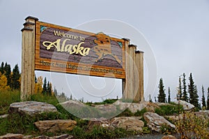
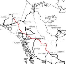
The Alaska Highway
Dawson Creek, British Columbia to Delta Junction, Alaska
(historical routes, heritage sites, sightseeing, driving tour)
Pioneer Road - Contract Road - Public Road

Travel along the Alaska Highway via the Historic Mileposts

Alaska Highway Sign
Dawson Creek, British Columbia

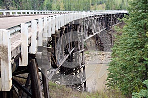
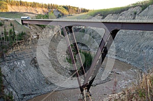
Alaska Highway Historic Milepost 21 Kiskatinaw Bridge/Wallace A. MacKey Ltd

The task of the United States Army Corps of Engineers was to build a pioneer road for military traffic from Dawson Creek to Big Delta, Alaska. This meant fording rivers and creeks in the most expedient, if not permanent, way possible. The responsibility for creating a more durable, all season highway fell to civilian contractors who followed closely behind the troops and were coordinated by the United States Public Roads Administration.

Though there were many timber bridges built by these civilian workers, the Kiskatinaw Bridge is the only one still in use. It is also one of the most unusual, curving nine degrees along its 162.5 metre (534 foot) length.

The bridge, the first of its kind in Canada, was built in 1942-43 by Dow Construction of Toronto. Cement footings were put in place in November 1942 using gravel hauled 26 kilometres (16 miles) from a crushing plant at the Peace River. An extreme cold snap that month made it necessary to enclose all concrete pedestals and piers and keep them heated to 22 degrees celsius (72 degrees fahrenheit) for 10 days. This was no mean feat given that the work involved almost 610 cubic metres (800 cubic yards) of concrete.

The bridge is a three span, timber truss structure built 30 metres (100 feet) above the stream. Approximately 500,000 board feet of creosoted British Columbia fir were used in its construction. The fir was shipped from coastal B.C. to the railhead at Dawson Creek. It should have arrived in early 1943, well before spring thaw, but was not delivered until April. Breakup made for a tough haul through the mud from Dawson Creek. Further construction delays occurred when the temporary log bridge and much of the scaffolding were damaged by spring runoff that year and had to be replaced.

Alaska Highway Historical Wooden Bridge
Alaska Highway Historic Mile 21

WWII Vintage Kiskatina River Bridge
Alaska Highway Historic Mile 21

This three-span timber truss bridge has an amazing nine-degree curve along its 162.5 m (534 foot) length – a curve that US PRA engineers designed to accommodate the highway’s hairpin curve. At the time, it was the first wooden curved bridge to be built in Canada.

In addition to the challenge of building a significant curve into a wooden bridge, the US PRA had to contend with assembling masses of materials, shipping delays, floods and unusual temperatures – all of which extended the construction time to nine months. About 500,000 board feet of creosoted British Columbia fir had to be shipped from the coast. Gravel had to be hauled 16 km in from a Peace River crushing plant. An unseasonal cold snap halted the curing of the cement poured to create the bridge’s pedestals and piers, which meant the construction crew had to prevent the curing concrete from freezing. They did this by enclosing the concrete and keeping it to a temperature of 22°C (72°F) for 10 days. This was extremely difficult given that the work involved almost 610 cubic m (800 cubic yards) of concrete.

There are two bridges in this area: the new Kiskatinaw Bridge (opened fall 1978) and the original Kiskatinaw Bridge, also known as the Historic Kiskatinaw Curved Bridge (built 1942-43). The historic bridge, located just north of Dawson Creek, British Columbia, is the only original timber bridge built by the US Public Roads Administration (PRA) that is still in use.

Alaska Highway Kiskatina River Steel Bridge
Alaska Highway Historic Mile 21

Unique as it was, a major drawback appeared as the region developed and oil and gas companies sent heavier trucks into the area: the bridge could only handle loads under 25 tonnes. Trucks over that weight had to ford the river; therefore, the new bridge was built in 1978. The old bridge remains on a former alignment of the highway.

In the postwar years, trucks with loads that exceeded the bridge’s maximum 25-tonne capacity had to avoid the bridge and ford the river instead. This proved especially inconvenient for the expanding oil and gas industry and, in 1978, a new road was built that bypassed the bridge and, so secured its survival. Kiskatinaw Provincial Park provides access to the river and interesting views of the bridge's structure.

Kiskatinaw Provincial Park
Old Alaska Highway Historic Milepost 21


The campsites are large and well spaced in a mixed forest.

Approximately 35 km north of Dawson Creek on Highway 97 turn east onto the Old Alaska Highway. Follow the road for approximately 2.5 km where there is a fork in the road and follow the road to the left until you reach the campground.

  • Operator or sponsor is: BC Parks
  • Nearby town or city: Dawson Creek
  • Total campsites: 28
  • Unserviced campsites: 28
  • Tent camping sites are available
  • Tables provided at campsites
  • Pump water available
  • Pit toilets
  • Playground
  • Day use area
  • Wheelchair access
  • Horseshoe pits

More information and photo's at Campscout.com

Website powered by Network Solutions®