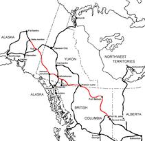
Dawson Creek, British Columbia to Delta Junction, Alaska (historical routes, heritage sites, sightseeing, driving tour) Pioneer Road - Contract Road - Public Road
� Robert M. Braley Jr. | Dreamstime.com
HISTORY - Pre-Construction The Northwest Staging Route
The Northwest Staging Route was a series of airstrips, airport and radio relay stations built in Alberta, British Columbia, the Yukon and Alaska during World War II. It extended into the Soviet Union as the ALSIB (ALaska-SIBerian air road).
The route was developed in 1940/1 due to several reasons. Initially, the United States Army Air Corps 7th Ferrying Group, Ferrying Command (later Air Transport Command) at Great Falls Army Airfield was ordered to organize and develop an air route to send assistance to Russia though Northern Canada, across Alaska and the Bering Sea to Siberia, and eventually over to the Eastern Front. The Permanent Joint Board on Defense — Canada and the United States — decided in the autumn of 1940 that a string of airports should be constructed at Canadian expense between the city of Edmonton in central Alberta and the Alaska-Yukon border. Late in 1941 the Canadian government reported that rough landing fields had been completed. The Alaska Highway would follow this same route as they would support each other.
With the outbreak of war, American lines of communication with Alaska by sea were seriously threatened and alternative routes had to be opened. The string of airports through the lonely tundra and forests of northwest Canada provided an air route to Alaska which was practically invulnerable to attack, and it seemed to be in the best interests of international defense to develop them and open a highway which would at once be a service road for the airports and a means for transporting essential supplies to the Alaskan outposts. In response to this need, the United States Army engaged in the Alaskan Highway project.
The Eleventh Air Force, the United States Army military installations, or the Lend-Lease aid to the Soviet Union could not wait for the Alaska Highway to be completed. The long route though the Caribbean to Brazil and across Africa to Iran was unworkable, nor could aircraft be flown via Greenland or Iceland. A huge program of airport construction and road making, therefore, was undertaken.
The Alaska Highway was but a part of the defenses provided for the Northwest and North American frontier. Much less is known about the great air route leading from the United States to Alaska through Canada than the Alaska Highway. Airfields were built or upgraded every 100 mi (160 km) or so from Edmonton, Alberta to Fairbanks, Alaska ("the longest hop being the 140 miles or so between Fort Nelson and the Liard River flight strip") The route of the Alaska Highway, which was built to provide a land route to Alaska, basically connected the airfields together. Edmonton became the headquarters of the USAAF Alaskan Wing, Air Transport Command.
Two routes were developed from the United States, which met at Edmonton, Alberta, from which the aircraft were ferried to Ladd Field, near Fairbanks, Alaska where the American-built aircraft were to be turned over to Russian flight crews. Marks Army Airfield, near Nome, Alaska was 500 miles closer to Russia, but was ruled out because the United States feared it was too vulnerable to Japanese attack. One route originated at Great Falls Army Air Base, Montana, where aircraft bound for Russia were ferried from their manufacturing plants in Southern California.
The other route originated at Minneapolis, Minnesota, where Wold-Chamberlain Airport was used as an aircraft staging point for aircraft manufactured in the Midwest and northeastern United States. The Minneapolis-Edmonton route, however was turned into a transport route only by the end of 1943, with aircraft ferrying operations being shifted to Great Falls. In addition to the Lend-Lease aircraft, Alaskan Eleventh Air Force aircraft were also ferried up the NSR, with the aircraft being flown to Elmendorf Field, near Anchorage from RCAF Station Whitehorse upon their arrival.