Alaska "And Beyond" Storyteller Photography

© Robert M. Braley Jr., Photographer


Home

Family Genealogy

Braley Genealogy

Eures Genealogy

United States

Route 66

USAstatestable

Alabama

Alaska Highway

Milepost

Klondike Gold Rush

NWSR History

NWSR Aircraft

NWSR Other Uses

NWSR Airfields

Highway Proposals 1920s

Canol Pipeline 1942

Hwy Const Start 1942

Hwy Post War Trans 1946

Alaska Hwy Route Markings

Hwy Route Description

Hwy Bypassed Rd Segments

Alaska Hwy Today

Alaska

Alaska Highway BC

Dawson Creek AH0000

Kaskatinaw River AH0021

Taylor AH0035

Fort St John AH0047

Charlie Lake AH0052

Beatton River AH0073

WonOWon AH0101

Pink Mountain AH0143

Suicide Hill AH0148

Buckinghorse River AH0175

Trutch Mt Summit AH0191

Adsett Creek AH0234

Fort Nelson AH0300

Tetsa River AH0375

Summit Lake 0392

Toad River AH0422

Muncho Lake AH0456

Liard Hot Springs AH0496

Smith River AH0514

Contact Creek AH0588

Teslin AH0604

Yukon Border AH0627

BC Border AH 0627

Alaska Highway YT

Watson Lake AH0635

Cassiar Hwy AW0649

Nugget City AH0650

Rancheria River AH0710

Cont Divide Lodge AH0721

Swift River AH0733

Johnsons Crossing AH0836

Marsh Lake AH0890

Whitehorse AH0905

Whitehorse AH0915

Canyon Creek AH0941

Pine Lake AH1010

Hanes Junction AH1016

Kllane Lake AH1067

Destruction Bay AH1083

Snag Junction AH1188

Burwash Landing AH1093

Beaver Creek AH1202

Alaska Highway AK

US Border AH1221

Border City AH1225

Tetlin AH1229

Deadman Lake AH1249

Deadman Lake CG AH1254

Lake View CG AH1257

Northway JCT AH1264

Taylor Hwy AH1306

Tok River AH1309

Tok Cutoff AH1314

Moon Lake AH1332

Delta Junction AH1422

Arizona

Arkansas

California

Colorado

Connecticut

Delaware

Florida

Georgia

Hawaii

Kansas

Kentucky

Idaho

Illinois

Indiana

Louisiana

Iowa

Maine

Maryland

Massachusetts

Michigan

Minnesota

Mississippi

Missouri

Montana

Nebraska

Nevada

New Hampshire

New Jersey

New York

New Mexico

North Carolina

North Dakota

Ohio

Oklahoma

Oregon

Pennsylvania

Rhode Island

South Carolina

South Dakota

Tennessee

Texas

Utah

Vermont

Virginia

Washington

Washington D.C.

Wisconsin

West Virginia

Wyoming

Canada

British Columbia

70 Mile House BC

100 Mile House

108 Mile House

Hope BC

Stewart BC

Stewart Cassiar Hwy

Chetwynd

Clinton BC

Fraser River Valley

Hudsons Hope

Huston BC

Pouce Coupe BC

Dawson Creek VC

Dawson Creek DT

Yukon

Crete

Equator

Israel

Products

Nature

Animals

Flowers

Landscapes

Sunset

Wildflowers

Wildlife

Fish

Birds

Albatrosses

Canada Goose

Comorants

CaracarasFalcons

DucksGeeseSwans

Frigatebirds

Grebes

Loons

Osprey

PartridgesGrouse

Pelicans

redwingedblackbird1

HawksKitesEagles

ShearwatersPetrels

StormPetrels

Bats

Vultures

Mammals

Black Bear

bison

BitternsHeronsEgr

Caribou

Carnivorans

Cetaceans

Dall Sheep

Deer

Moose

Mountain Goat

Seals Sea Lions Walrus

Orca

Pikas Hares Rabbits

Polar Bear

Primates

Raccoons

Rodents

Great blue heron

Shrews

Bears

Beaver

Ungulates

Weasels

Military

Alaska Air National Guard

Kulis Air National Guard

Soldiers of the Mists pdf

Soldiers of the Mists

C-17

T-6G

T-33

P-51 Mustang

KC-135

HH-60

F-86

F-80

C-47

HC-130N

C-130H

C-130E

C-123J

Alaska National Guard

Camp Murray

Alaskanized

Ladd AFB

AKNG Museum

U-Tapao

The Salvation Army

Pixels

links

Biography

About

Policy/Copyright

Contact

Robert M Braley Jr

Family

Finance

Photo Sizes

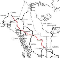
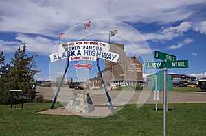
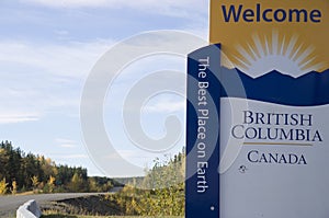
The Alaska Highway
Dawson Creek, British Columbia to Delta Junction, Alaska
(historical routes, heritage sites, sightseeing, driving tour)
Pioneer Road - Contract Road - Public Road


Alaska Highway Sign
© Robert M. Braley Jr. | Dreamstime.com

Charlie Lake, British Columbia, Canada
Alaska Highway Historic Mile 52

Charlie Lake is a lake in north-eastern British Columbia, Canada, situated 8 km (5.0 mi) west from Fort St. John, along the Alaska Highway. The lake provides the water supply for the city of Fort St. John. The Charlie Lake Formation, a stratigraphical unit of the Western Canadian Sedimentary Basin is named for the lake.
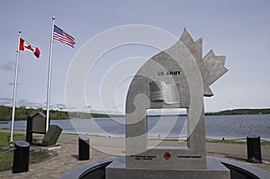
Source: Wikipeda

Historic Mile 52 Charlie Lake Mile 0 Army Tote Road. Site of a major distribution camp for workers and supplies heading north. Three American soldiers also drowned here in 1942 while crossing the lake aboard “pontoon bargers.”

WWII Vintage Military Memorial
© Robert M. Braley Jr. | Dreamstime.com

Metal United States Flag
© Robert M. Braley Jr. | Dreamstime.com

Alaska Highway Stone Mountain Sheep
© Robert M. Braley Jr. | Dreamstime.com

 
The park is located 11 km north of Fort St. John at the junction of the Alaska Highway and Highway 29

There are a variety of campsites with gravel pads, some are large and most are sheltered by spruce trees. A couple of the sites are lakeside. This campground is pack in pack out for garbage.

The campsites are large, on gravel pads with lots of trees which are mostly aspen.

  • Operator or sponsor is: BC Parks
  • Nearby town or city: Fort St. John
  • Total campsites: 57
  • Unserviced campsites: 57
  • Tables provided at campsites
  • Tap water available
  • Pit toilets
  • Recycling collection at campground
  • Sewage dumping station
  • Hiking trails
  • Playground
  • Picnic shelter
  • Day use area
  • Wheelchair access
  • Horseshoe pits
  • Boat launch

Approximaely 70 km (45 miles) northwest of Fort St. John on Highway 97 (Alaska Highway).

  • Operator or sponsor is: BC Recreation Sites & Trails
  • Nearby town or city: Fort St. John
  • Total campsites: 16
  • Unserviced campsites: 16
  • Tables provided at campsites
  • Pit toilets
  • Boat launch

More information and photos at Campscout.com

British Columbia Canada
© Robert M. Braley Jr. | Dreamstime.com


Become a image contributor at Dreamstime (as your stock photography agent) and start selling your camera and/or cell phone travel and other images. Learn how by clicking on a banner above.

Website powered by Network Solutions®