Hope is a district municipality located at the confluence of the Fraser and Coquihalla rivers in the province of British Columbia, Canada. Hope is at the eastern end of both the Fraser Valley and the Lower Mainland region, and is at the southern end of the Fraser Canyon. To the east over the Cascade Mountains is the Interior region, beginning with the Similkameen Country on the farther side of the Allison Pass in Manning Park. Located 154 kilometres (96 mi) east of Vancouver, Hope is at the southern terminus of the Coquihalla Highway and the western terminus of the Crowsnest Highway, locally known as the Hope-Princeton (Highways 5 and 3, respectively), where they merge with the Trans-Canada Highway (Highway 1). Hope is at the eastern terminus of Highway 7. Hope is a member municipality of the Fraser Valley Regional District which provides certain municipal services to unincorporated settlements and rural areas.
History
First Nations History
Hope's First Nations settlement period starts with the first traces of people living in the Fraser Valley. These first nation origins date from 8,000 to 10,000 years ago, when the Sto:lo First Nations were in the area. In late 1782 a smallpox epidemic among the Stó:lō killed thousands or an estimated two thirds of the population.
European History
The European settlement period of Hope history begins in 1808. Explorer Simon Fraser arrived in what is now Hope in 1808, and the Hudson's Bay Company created the Fort Hope trading post in 1848. The area was transformed by the Fraser Canyon Gold Rush, beginning in 1858. The following year Governor James Douglas laid out the Fort Hope town site. Hope became part of the Colony of British Columbia when the new British colony was created on 2 August 1858. Along with the rest of British Columbia, Hope became part of Canada in 1871. Late in 1859, Reverend Alexander St. David Francis Pringle arrived in Hope. On 1 December of that year, he founded the first library on the British Columbia mainland. Within two years, he founded Christ Church (Anglican). Today, Christ Church is the oldest church on the B.C. mainland still holding services on its original site and is a National Historic Site of Canada. Hope incorporated as a village on 6 April 1929, became a town on 1 January 1965, and was reincorporated as a District Municipality named the District of Hope on 7 December 1992.
WWII
During World War II an internment camp for Japanese Canadians was set up near Hope at Tashme (today's Sunshine Valley) just beyond the 100-mile exclusion zone from the coast.
Geography
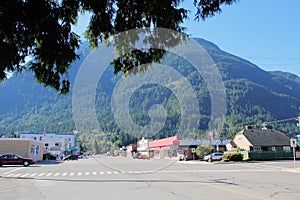
Hope is at the easternmost point of British Columbia's lower mainland area and is usually considered to be part of the Fraser Canyon area or "eastern Fraser Valley" as "Lower Mainland" is commonly understood as synonymous with "greater Vancouver". There are relatively significant peaks to the north, east, and south of the townsite. Only to the west can flat land be seen, and that view is dominated by the broad lower reaches of the Fraser River. The segment from Lytton to Hope separates the Cascade Mountains and Coast Mountains, thereby forming the lower part of the Fraser Canyon, which begins far upriver near Williams Lake. At Hope, the river enters a broad flood plain extending 130 kilometres (81 mi) to the coast and Vancouver. The Coquihalla and Sumallo Rivers and Silverhope Creek rise in the Cascade Mountains northeast and southeast and south of Hope, respectively, and empty into the Fraser River. The Skagit River begins south of Hope, across a low pass from the head of the Silverhope valley, which is the access to the Canadian shoreline of Ross Lake.
Arts and Culture
Chainsaw and Wood Carving
Hope holds chainsaw wood carving competitions and exhibitions. From 4–7 September 2008 the Second Annual Hope Chainsaw Carving Competition took place. Chainsaw wood carvings are displayed and exhibited throughout the downtown core of Hope. Memorial Park in downtown Hope has a display of chainsaw wood carvings. Hope is home to a notable widely known carver named Pete Ryan who has carved a number of the chainsaw wood carvings exhibited in downtown Hope.
Hope Arts Callery
The Hope Arts Gallery exhibits and sells a variety of art by local artists. The Hope Arts Gallery is located in downtown Hope and has several rooms displaying sculpture, pottery, paintings and drawings, jewellery, fabric arts, basketry, cards and gifts, and photography. The Hope Arts Gallery is run by volunteers from the Hope Arts Guild. The Hope Arts Gallery presents ART WALK, a self-guided tour to art and chainsaw wood carvings in Hope.
Hope Brigade Days
One of the largest events of the year in Hope is Hope Brigade Days. Brigade Days weekend occurs the weekend after Labour Day every September. Events include a parade, fireworks display, midway, chainsaw carving competition, demolition derby, kids' carnival, and 4x4 racing.
Attractions
Hope Museum
The Hope Museum shows the history, culture and heritage of Hope. In downtown Hope, together with the Hope Visitor Centre, the Hope Museum is open year round. Exhibits include First Nations culture, early Fort Hope, the Fraser Canyon Gold Rush, the Kettle Valley Railway, pioneer life, logging, and mining.
Memorial Park and Friendship Garden
Immediately adjacent to the District Hall in Hope is a Japanese garden called the Friendship Garden, dedicated to the Japanese-Canadians who were interned nearby at Tashme during World War II. It was built by local Japanese-Canadians, and presented to Hope on July 27, 1991. Men from that camp were employed during the war building the Hope-Princeton Highway.